
File:Durham 1610.jpg
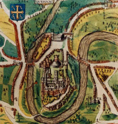
A map of Durham, England from 1610, by the famous cartographer John Speed. The cathedral and castle are shown, as is the River Wear which surrounds the city on three sides.
| This image is in the public domain because under United States copyright law, originality of expression is necessary for copyright protection, and a mere photograph of an out-of-copyright two-dimensional work may not be protected under American copyright law. The official position of the Wikimedia Foundation is that all reproductions of public domain works should be considered to be in the public domain regardless of their country of origin (even in countries where mere labor is enough to make a reproduction eligible for protection). | ||||
|
||||

 |
This is a candidate to be copied to Wikimedia Commons. Freely licensed or public domain media are more accessible to other Wikimedia projects if placed on Commons. Any user may perform this move—please see Moving images to the Commons for more information. Please thoroughly review the copyright status of this file and ensure that it is actually eligible for transfer to Commons. If you are concerned that this file could have problems with its attribution information and/or copyright status, then remove this notice and DO NOT transfer it to Commons. By transferring this file to Commons, you acknowledge you have read this message and are willing to accept any and all consequences for inappropriate transfers. Repeat violators will be blocked from editing. If you have checked the file and it is OK to move to Commons add "|human=username" to the template so other users can see it has been checked and can help you copy the file to Commons. If the file has already been moved to Commons, then consider nominating the file for deletion or changing the template to {{Already moved to Commons}} If the file can't be moved to Commons because it doesn't fit Common's scope, then use {{Do not move to Commons|reason=Why it can't be moved to Commons}} If you think that a local copy of this file should be kept, then use {{Keep local}}. Consider using {{Keep local|reason=Why the English Wikipedia needs a local copy}} Copy to Commons: via CommonsHelper |
||
|
|||
File usage
Metadata
Background information
All five editions of Schools Wikipedia were compiled by SOS Children's Villages. SOS Childrens Villages believes that a decent childhood is essential to a happy, healthy. Our community work brings families new opportunities through education, healthcare and all manner of support. Sponsoring a child is a great way to help children who need your support.