Tropical Storm Vamei
About this schools Wikipedia selection
SOS Children has tried to make Wikipedia content more accessible by this schools selection. SOS Children is the world's largest charity giving orphaned and abandoned children the chance of family life.
| Tropical storm ( JMA) | |
|---|---|
| Category 1 typhoon ( SSHS) | |
 |
|
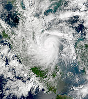
| Vamei shortly before landfall | |
| Formed | December 26, 2001 |
| Dissipated | December 28, 2001 |
| Highest winds | 10-minute sustained: 85 km/h (50 mph) 1-minute sustained: 140 km/h (85 mph) |
| Lowest pressure | 1006 mbar ( hPa); 29.71 inHg |
| Fatalities | 5 direct |
| Damage | $3.6 million (2001 USD) |
| Areas affected | Singapore, Malaysia, Indonesia |
| Part of the 2001 Pacific typhoon season 2001 North Indian Ocean cyclone season |
|
Tropical Storm Vamei (international designation: 0126, JTWC designation: 32W, sometimes called Typhoon Vamei; formerly had the alternate name Tropical Storm 05B) was a Pacific tropical cyclone that formed closer to the equator than any other tropical cyclone worldwide. The last storm of the 2001 Pacific typhoon season, Vamei developed on December 26 at 1.4° N in the South China Sea. It strengthened quickly and made landfall along extreme southeastern Malaysia. Vamei rapidly dissipated over Sumatra on December 28, and the remnants eventually re-organized in the North Indian Ocean.
Though officially designated as a tropical storm, the intensity of Vamei is disputed; some agencies classify it as a typhoon, based on sustained winds of 140 km/h (85 mph) and the appearance of an eye. The storm brought flooding and landslides to eastern Malaysia, causing $3.6 million in damage (2001 USD, $4.2 million 2007 USD) and five deaths. The typhoon is named after a songbird with white feathers; contributed by Macau, the name was retired after its first and only usage.
Storm history
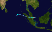
On December 19, a small low-level circulation was located along the northwest coastline of Borneo; at the same time a plume of cold air progressed southward through the South China Sea on the southeastern periphery of a ridge over the Far East. The vortex drifted southwestward, reaching open water by December 21. The northerly air surge was deflected after interacting with the circulation, and at the same time a portion of the air surge crossed the equator. The southerly flow turned eastward, then northward, and in combination with the northerly flow it wrapped into the vortex, resulting in rapid development of the low-level circulation, just a short distance north of the equator. By December 25, an area of scattered convection persisted about 370 km (230 mi) east of Singapore within an area of low wind shear, in association with the low-level circulation. Continuing slowly westward, the convection deepened and organized further, and at 1200 UTC on December 26 the disturbance developed into a tropical depression about 230 km (145 mi) east of Singapore, or 156 km (97 mi) north of the equator. This was the first recorded occurrence of a tropical cyclone near the equator.
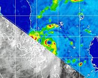
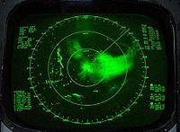
The depression strengthened further and officially attained tropical storm status at 0000 UTC on December 27, based on the analysis by the Japan Meteorological Agency (JMA), though the Joint Typhoon Warning Centre (JTWC) unofficially classified it as a tropical storm six hours prior. Shortly thereafter, an eye with a 39 km (24 mi) diameter became apparent on satellite imagery, along with rainbands extending southward to the opposite side of the equator. At 0600 UTC, the JMA first classified the system as Tropical Storm Vamei, about 65 km (40 mi) northeast of Singapore, and the agency estimated the storm attained peak winds of 85 km/h (50 mph) at the same time. However, the JTWC upgraded Vamei to typhoon status with peak winds of 140 km/h (85 mph), based on a United States Navy ship report from within the eye; a second ship reported wind gusts of 195 km/h (120 mph) in the southern portion of the eyewall. The storm was small and compact, with gales extending about 45 km (30 mi) from its centre. At about 0830 UTC on December 27, Vamei made landfall approximately 60 km (35 mi) northeast of Singapore, in the southeastern portion of the Malaysian state of Johor. Initially, the Malaysian Meteorological Department classified the cyclone as a tropical storm, though it was later re-assessed as a typhoon at landfall.
Tropical Storm Vamei weakened quickly as it crossed the extreme southern portion of the Malay Peninsula, and late on December 27 the JMA downgraded it to tropical depression status before the cyclone emerged into the Straits of Malacca. The JTWC initially maintained it as a minimal tropical storm, though the agency downgraded the storm to depression status as the centre again approached land. Early on December 28, Vamei moved ashore along northeastern Sumatra, and at 0600 UTC the JMA classified the storm as dissipated. However, convection persisted near the circulation over land, believed to have been caused by the process known as upper-level diffluence. On December 29, what was originally believed to be a separate system reached the southeastern Bay of Bengal. In a post-season re-evaluation, the JTWC classified the system as a continuation of Vamei, based on analysis of satellite imagery that indicated the circulation of Vamei crossed Sumatra without dissipating. Convection re-developed, and late on December 30 the JTWC classified the cyclone as a tropical storm about 390 km (245 mi) west-southwest of the northwestern tip of Sumatra; initially, due to being treated as a separate system, it was classified as Tropical Cyclone 05B. Vamei quickly developed good outflow and organization, though increased wind shear on December 31 rapidly weakened the storm; by late that day, the centre was exposed from the deep convection, and Vamei quickly dissipated.
Unusual formation
Vamei formed and reached tropical storm strength at 1.5º N, only 156 km (97 mi) from the equator. This broke the previous record of Typhoon Sarah in the 1956 Pacific typhoon season, which reached tropical storm strength at 2.2º N. Due to a lack of Coriolis effect near the equator, the formation of Vamei was previously considered impossible. However, a study by the Naval Postgraduate School indicated that the probability for a similar equatorial development was at least once every four centuries.
Vamei developed a vortex that appears every winter along the northwest coast of Borneo and is maintained by the interaction between monsoonal winds and the local topography. Often, the vortex remains near the coastline, and in an analysis of 51 winters, only six reported the vortex as being over the equatorial waters for four days or more. As the area in the South China Sea between Borneo and Singapore is only 665 km (415 mi) wide, a vortex needs to move slowly to develop. A persistent northerly wind surge for more than five days, which is needed to enhance the vortex, is present, on average, nine days each winter. The probability for a pre-existing tropical disturbance to develop into a tropical cyclone is between 10–30 percent. Thus, the conditions which resulted in the formation of Vamei are believed to occur once every 100–400 years.
Preparations and impact
Four days prior to Vamei moving ashore, the Malaysian Meteorological Department (MMD) issued storm advisories for potentially affected areas. Subsequently, the agency issued warnings for heavy rainfall, rough winds, and rough seas. However, few citizens knew of the passage of the rare storm.
Offshore of Malaysia, two U.S. Navy ships in Vamei's eyewall were damaged by strong winds. Upon moving ashore, the storm brought storm surge damage to portions of southeastern Malaysia. Vamei brought strong winds and heavy rainfall to portions of Melaka, Negeri Sembilan, and Selangor as well as to Johor, where rainfall reached over 200 mm (8 in) in Senai. Additionally, monsoonal moisture, influenced by the storm, produced moderate to heavy precipitation across various regions of peninsular Malaysia. The passage of the cyclone resulted in flooding and mudslides, which forced the evacuation of more than 13,195 people in Johor and Pahang states into 69 shelters. Along Gunung Pulai, the rainfall caused a landslide which destroyed four houses and killed five people. River flooding was also reported, as a result of the precipitation from Vamei as well as previous rainfall. Damage from the flooding was estimated at RM13.7 million (2001 MYR, $3.6 million 2001 USD). About 40 percent of the damage occurred to crops at a farm in Kota Tinggi. Moderate damage to transportation, education, and health-care facilities was also reported. The Malaysian government provided affected families up to RM5,000 (2001 MYR, $1,300 2001 USD) in assistance for food, clothing, and repairs. Vamei also brought heavy rainfall to Singapore, which caused air traffic disruptions at the Singapore Changi Airport. The passage of the cyclone resulted in many downed trees.
In 2004, the name "Vamei" was retired and replaced with "Peipah", becoming the first retired name since the Japan Meteorological Agency began naming Pacific typhoons in 2000. Vamei was one of two tropical cyclones in the current naming list that was retired without attaining typhoon status; the other was Tropical Storm Bilis in 2006.


