Lake Mead
About this schools Wikipedia selection
Arranging a Wikipedia selection for schools in the developing world without internet was an initiative by SOS Children. Do you want to know about sponsoring? See www.sponsorachild.org.uk
| Lake Mead | |
|---|---|
 |
|
| Location | Nevada and Arizona |
| Coordinates | 36°03′35″N 114°46′35″W |
| Lake type | reservoir |
| Primary inflows | Colorado River |
| Primary outflows | Colorado River |
| Basin countries | United States |
|
|
|
| Max. length | 110 mi (180 km) |
| Surface area | 248 mi² (640 km²) |
| Water volume | 35.2 km³ |
| Shore length1 | 550 mi (885 km) |
|
|
|
| 1 Shore length is not a well-defined measure. | |
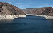
Lake Mead is the largest man-made lake and reservoir in the United States. It is located on the Colorado River about 30 miles (48 km) southeast of Las Vegas, Nevada, in the states of Nevada and Arizona. Formed by water impounded by Hoover Dam, it extends 110 mi (180 km) behind the dam, holding approximately 28.5 million acre feet (35 km³) of water. The water held in Lake Mead is released to communities in southern California, via aqueducts, and Nevada.
History
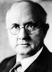
The lake was named after Elwood Mead, who was commissioner of the U.S. Bureau of Reclamation from 1924 to 1936 during the planning and construction of the Boulder Canyon Project that created the dam and lake. Lake Mead was established as the Boulder Dam Recreation Area in 1936, administrated by the National Park Service. It was then changed to the Lake Mead National Recreation Area in 1964, this time including Lake Mohave and the Shivwits Plateau under its jurisdiction. Both lakes and the surrounding area offer year-round recreation options. The accumulated water from Hoover Dam forced the evacuation of several communities, most notably St. Thomas, Nevada, whose last resident left the town in 1938. The ruins of St. Thomas are sometimes visible when the water level in Lake Mead drops below normal.
The 1983 high-water mark or "bathtub ring" is visible in photos that show the shoreline of Lake Mead. The bathtub ring is white because of the deposition of minerals on previously submerged surfaces.
Geography

Access from the northwest from Interstate 15 is through Valley of Fire State Park and the Moapa River Indian Reservation.
The lake is divided into several bodies. The large body closest to the Hoover Dam is Boulder Basin. The narrow channel, which was once known as Boulder Canyon and the original planned site for the dam is now known as The Narrows, connects Boulder Basin to Virgin Basin to the east. The Virgin River and Muddy River empty into Overton Arm, which is connected to the northern part of the Virgin Basin. The next basin to the east is Temple Basin, and following that is Gregg Basin.
Jagged mountain ranges surround the lake, offering somewhat of a startling but beautiful backdrop, especially at sunset. There are two mountain ranges within view of the Boulder Basin, the River Mountains, oriented North-west to South-east and the Muddy Mountains, oriented West to North-east.
Most expect to see lush vegetation to be growing on the shores of the lake but since Lake Mead is a reservoir the water level does not usually stay constant long enough to sustain trees or bushes. Aside from that the flora that is native to here is adapted to having less water and would most likely die off with the abundance of water.
Las Vegas Bay is the terminus for the Las Vegas Wash which is the sole outflow from the Las Vegas Valley.
Drought

As of February 2008, the lake is currently at 50.44 percent of its capacity, threatening to make the Las Vegas valley's primary raw water intake inoperable. Though the small rise since last year has eased the current crisis, if the lake doesn't receive enough inflow this spring, problems may arise later this summer. Arrangements are underway to pipe water from elsewhere in Nevada by 2011, but since the primary raw water intake at Lake Mead could become inoperable as soon as 2010 based on current drought and user projections, Las Vegas could suffer crippling water shortages in the interim. Lake Mead draws a majority of its water from snow melt in the Western Colorado Rockies. Since 2000 the water level has been dropping at a fairly steady rate due to less than average snowfall. As a result, marinas and boat launch ramps have either needed to be moved to another part of the lake or have closed down completely.
Further research in February of 2008 by the University of California in San Diego led researchers to conclude that, if future climate changes as projected and water use "is not curtailed," Lake Mead's water level could drop below the dead storage elevation by 2021, and that the reservoir could drop below minimum power pool elevation as early as 2017.
Recreation
Lake Mead offers many types of recreation to locals and visitors. Boating is the most popular. Additional activities include fishing, water skiing, swimming, and relaxing in the sun. There are several marinas on the lake that rent luxury houseboats: Forever Resorts and Seven Crowns . With other smaller ones that rent small boats. The area also has many coves with rocky cliffs and sandy beaches to explore. There are several small to medium-sized islands in the lake area depending on the water level. In addition, the Alan Bible Visitor Centre has a small cactus garden of plants native to the Mojave Desert.
At the bottom of the pool is a B-29 Superfortress that crashed while performing secret experiments. It has been acknowledged that one of the then classified instruments on board used to take atmosphere measurements was called "Suntracker".


