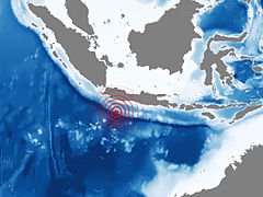
July 2006 Java earthquake
Background to the schools Wikipedia
This selection is made for schools by a children's charity read more. Click here to find out about child sponsorship.
|
|
|
| Date | 17 July, 2006 |
|---|---|
| Magnitude | 7.7 Mw |
| Countries or regions | Indonesia |
| Casualties | At Least 659 |
The July 2006 Java earthquake was a magnitude 7.7 earthquake off the southwestern coast of Java, Indonesia. It occurred on July 17, 2006, at 08:24 UTC (15:24 local time).
The U.S. Geological Survey placed the epicentre of the quake at 9.295° S 107.347° E, and its hypocentre at a depth of 48.6 km below the seabed. This is 225 km (140 miles) NE of Christmas Island, 240 km (150 miles) SSW of Tasikmalaya, Indonesia, and 358 km (222 miles) S of Jakarta, the capital and largest city of Indonesia.
Cause
According to the U.S. Geological Survey "The earthquake occurred as a result of thrust-faulting on the boundary between the Australia plate and the Sunda plate. On this part of their mutual boundary, the Australia plate moves north-northeast with respect to the Sunda plate at about 59 mm/year. The Australia plate thrusts beneath the Sunda plate at the Java trench, south of Java, and is subducted to progressively greater depths beneath Java and north of Java. The earthquake occurred on the shallow part of the plate boundary, about 50 km north of the Java trench."
Estimated casualties
The Ministry of Health (MOH) reports that approximately 668 people died, 65 are missing and 9,299 are in-treatment because of the disaster.
At least three non-Indonesian nationals were among the dead, including travellers from the Netherlands, Pakistan and Sweden. The Swedish foreign ministry reported that two Swedish children on holiday in the region were missing the first day; they were later found at safe ground higher up in the community.
| Deaths | Injured | Missing | Displaced | ||
|---|---|---|---|---|---|
| Confirmed | Estimated | ||||
| Total | 547 | 550 | 595 | 275 | 54,256 |
Aftershocks
The USGS recorded at least 22 aftershocks south of Java ranging between magnitude 4.6 and 6.1. The two largest aftershocks measured 6.0 and 6.1 Mw.
Tsunami
The July 2006 Java earthquake caused a three-meter-high tsunami which destroyed houses on the south coast of Java, killing at least 668 people and leaving at least 65 missing.
The tsunami smashed into a 110-mile stretch of Java’s coastline that was unaffected by the devastating 2004 Indian Ocean earthquake|2004 Indian Ocean tsunami. Waves more than 6 feet high reached 200 yards inland in some places, destroying scores of houses, restaurants and hotels. Cars, motorbikes and boats were left mangled amid fishing nets, furniture and other debris.
The tsunami struck the southern Indonesian coastal villages of Cipatujah and Pangandaran on the coast southeast of Bandung and Garut. There is reportedly extensive damage at the West Java beach resort of Pangandaran. Thousands of people at the resort fled to higher ground.
Localised tsunami
Following the earthquake, the Indonesian Meteorological and Geophysics Agency stated that “There is the possibility of a local tsunami that could affect coasts located usually no more than 100 kilometres from the earthquake epicentre”, indicating the improbability of a large-scale tsunami, like the one that affected Indonesia and other areas following the 2004 Indian Ocean earthquake on December 26, 2004. Despite this, India still issued a tsunami warning for the Andaman Islands archipelago region, which is located in the Bay of Bengal. This archipelago suffered severe damage in the December 26, 2004 tsunami. A warning was also issued for Christmas Island, however police reports from the island say that no damage was caused. A mere 60 cm tsunami was recorded at the Bureau of Meteorology’s tide gauge on the island. A warning was also issued for the Kimberley region of Western Australia.
Warning
The Pacific Tsunami Warning Centre in Hawaii issued a Tsunami bulletin 12 minutes after the earthquake alerting Indonesia (Java) and Australia (Christmas Island) to a possible local tsunami affecting coasts within a 100 km radius from the quake epicentre. The bulletin gave an estimated tsunami impact time for Indonesia of 09:00 UTC, an advanced warning of 24 minutes. It suggested that based on historical data, the risk of a destructive widespread tsunami was non-existent. The second bulletin issued two and a half hours later confirmed the occurrence of local tsunami by the news media and the reiteration that a more widespread tsunami was non-existent.
Kusmayanto Kadiman, the State Minister for Research and Technology confirmed that Indonesian officials had received bulletins from both the Pacific Tsunami Warning Centre in Hawaii and the Japan Meteorological Agency twenty minutes before the first tsunami wave struck. However, Kadiman indicated that the government did not publicise the bulletins because they did not want to cause unnecessary alarm. According to an AP report, he had stated the bulletins were received 45 minutes before the tsunami hit. He later stated that warnings were issued seven minutes before incident via text messaging but that it was not enough time to alert local communities.
Edi Prihantoro, an official at Indonesia’s Ministry of Research and Technology that oversees a national warning project, said the southern Java area had no system to warn people of coming waves.
As part of a five-year project to install tsunami buoys around the archipelago, Indonesia deployed two such devices off the island of Sumatra last year. However, when asked how many of the deployed devices were operational, Prihantoro replied: “None.” He continued, “We need at least 22 buoys to cover all of Indonesia. We have received two from Germany and they were deployed months ago. However, both of them are damaged now.” Both devices have since been decommissioned and one of them is awaiting repairs.
Evacuation
At least 23,000 people did eventually evacuate the coast, either afraid that more tsunami were coming or because their homes had been destroyed.

